Sunday, October 25, 2009

Off Trail Hike in Sanborn Park

It was one of these lazy Bay Area autumn mornings, sunny and not too hot. The hike started casually, to visit the Lake Ranch Reservoir and see if it already filled up with water. We quickly climbed to the reservoir and found that the water has cleaned since summer, no signs of smelly algae, but the level is still low. Continuing on the road past the reservoir, we walked by the creek paralleled with an old forest road. It looked like a good idea to turn right off the trail and check it out.


View Larger Map

The trail along the creek was overgrown and blocked with fallen trees. After a couple hundred meters we discovered an old water pipeline, probably a reminder from the days when the reservoir was privately owned.  A little dam on the creek used to fed water to the pipeline, which carried it to the reservoir. The dam is now destroyed.


Past the pipeline the trail disappeared and the creek started to climb up the bottom of a steep canyon. The forest was dark, moist, and full of  vegetation. The ferns were up to 2.5 meter tall. Dead trees, branches, and thick layer of leafs covered the ground. Our progress along the creek was slow because of the obstacles. It felt like a primal forest, though we found reminders of peoples activity in the creek: broken pipes, a water tank, and some cables.


Isia found some cool looking fungi that grew on dead branches under the ground, and two salamanders. I identified them on the web as Sierra Newt Salamander. The salamander had a very tight and muscular grip when walking on my hand. According to the web page description, this tight grip is developed during the mating season.


At some point the creek canyon was totally blocked by fallen trees, this is where we turned back.

Saturday, October 24, 2009

Deer Hollow Farm Volunteer Recognition Event

Isia volunteered at Deer Hollow Farm in Rancho San Antonio during the summer. She was taking care of the animal pens, and played with little goats and piglets after work. Today we drove her to the volunteer recognition event at the farm. The farm was closed for the visitors, and the event was held at the barn and the vegetable garden. Probably close to 100 people was there, volunteers and farm donors, staff from the City of Mountain View and the Open Space District, and the accompanying guests. I did not realize that so much work at the farm is done by volunteers, who contributed over 6000 hours in one year.

Rancho San Antonio and Deer Hollow Farm were the first park that we visited after coming to the Silicon Valley. I remember that I found the information about Rancho in the phone book in the section listing local parks. This was in 1993, before the internet. We are coming the the Rancho ever since.

Today's event at the farm had a lot of attractions. There was a live folk band playing in the barn, a lunch with dessert at the picnic tables, a  pumpkin ruffle, and a lot of interesting people around. Thanks to Isia, we were able to be part of it.


Here is Isia with Jen, the farm staff.


One of the goats that Isia was taking care of during the summer. I remember them when they were just born several months ago.


The live band was playing and singing through much of the event. The band was very entertaining, but I do not recall its name.


Lunch was topped off with the pumpkin and apple pies.


After lunch the volunteers were recognized with letters and gifts. Here is Isia receiving the volunteer recognition letter,


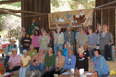
and here is the entire volunteer group.
.

After the event we walked back to the car on the Coyote Trail, which goes above the farm. In this picture the farm is hidden down in the valley behind.

Sunday, October 11, 2009

Ancient Oaks and Mindego Trails in the Russian Ridge OSP

Today we made a 6.5 mile hike along the Ancient Oaks and Mindego Trails in the Russian Ridge Open Space Preserve. These trails are located at the edges of canyons that channel a lot of fog and moisture, so there is a lot of green vegetation around. Because the day was cold and windy there was more wildlife then people. We have seen several rattlesnakes, deers, a coyote, and some curious looking spiders.  I like to come here, but it is a long 40 min. drive from Sunnyvale. Today I came to show the area to Alex and Peter, and the next time I want to come in the early springs when the hills are bright green.


Looking north-east from the Ancient Oaks Trail on this foggy and windy day. This is one of my favorite views in the preserve.


A magnificent oak at the Ancient Oaks Trail. This area receives more than average moisture from the fog and the trees are enclosed in moss, a fairytale scenery.


Black Mountain from the trail to Borel Hill.


We spotted three baby rattlesnakes along the trail.


We also noticed several larger spiders. What species are they?

Saturday, October 10, 2009

Mt. Price Loop in the Desolation Wilderness

We were backpacking in the Desolation Wilderness in October a year ago. It was so nice that I wanted to repeat it this year, with a condition that we will make a loop trip rather than hike and return on the same trail. After looking at several options, I found the Tahoe Backcountry web page with a description of the hike to the top of Mt. Price. The hike starts at the Wrights Lake and in part goes off the trail, cross-country. Our two day itinerary was:

Day 1: Wrights Lake, Island Lake, Mt. Price, Lyons Lake: 5.2 miles
Day 2: Lyons Lake, Lyons Lake trail head, Wrights Lake: 10.7 miles
Total: 15.9 miles


View Larger Map

On the way to the wilderness we stopped at the Pacific Ranger District to pick up the overnight permit. Ranger there said that there is a Snow Advisory above 5500 ft. for the evening, and I imagined ourselves sitting in the tent looking at the single snow flakes falling on the trees. With that thought we drove to the Wrights Lake and started to hike at noon. The day was sunny and windy, a good day for hiking.


At the Island Lake we stopped to rest and look-up the way, which from this point goes cross-country. Mt. Price is in the center of the picture, the second small peak from the left. The route goes up the slopes to the right side of the peak and then traverses to the pass at the left.


Going up we have seen a flock of funny looking Sooty Grouse, which hid in the tall grass and under the rocks when we came closer.


By the time we got to the top of the mountain, it was surround by dark clouds and the temperature significantly dropped. The plan was to traverse to Mt. Agassiz and then descend to Sylvia Lake, but the traverse was invisible under the dark clouds and the slopes leading to Lyons Lake were still clear. We choose to go down and camp at the Lyons Lake.


Our overnight camp was on the gully overlooking the lake at the left side of the dam that crosses the lake right to left. We rushed to the sleeping bags because of the cold and wind. Soon after that the thunderstorms started, and were followed by the snowfall.


In the morning the world outside looked very different then yesterday. It was still dawn when we got up, and the snow was swirling around the tent. We started to descend along the Lyons Creek to the main road. For the most part, the Lyons Creek Trail trail was visible under the 4 inch cover of snow.


Things cheered up when the sun came out, and there was more people on the trail - two groups were walking down from Sylvia Lake to the trail head.


Here is the view at the Wrights Lake at the end of the trip, and more pictures in the Picassa Album.